
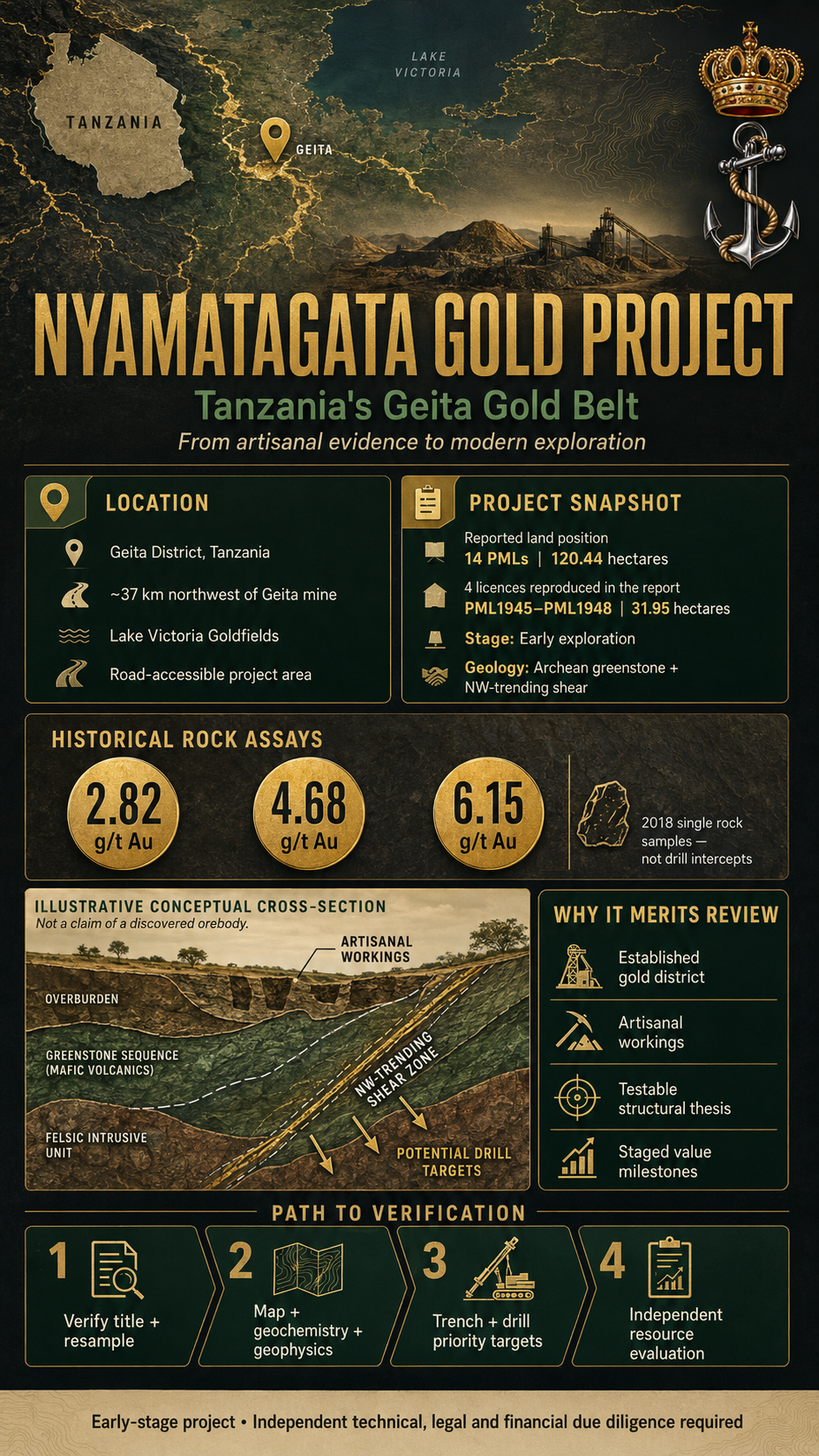
Historical rock assays reporting up to 6.15 grams per tonne, established artisanal workings and a strategic position within Tanzania’s Geita gold district give Nyamatagata a compelling foundation for systematic exploration.
In gold exploration, location matters—but geology, field evidence and disciplined verification matter even more.
The Nyamatagata Gold Project brings those elements together in Tanzania’s Geita District, part of the mineral-rich Lake Victoria goldfields. According to a geological report compiled by Dr. Beny Lugenga, the project is approximately 37 kilometres northwest of the established Geita mining operation and can be reached from Geita town by an all-weather road.
Nyamatagata is not being presented as a finished mine or a proven gold reserve. It is an early-stage opportunity to convert a promising geological setting, historical artisanal activity and encouraging rock samples into a modern, independently verified exploration project.
That distinction is important—and it is precisely where the opportunity may be found.
A Position Inside an Established Gold District
The project’s strongest strategic advantage is its address.
The Geita region has produced gold for generations. AngloGold Ashanti’s Geita mine began modern operations in 2000, while mining in the district dates back to the 1930s. The operator reports a Mineral Resource of 3.25 million ounces as of December 31, 2024, supported by a carbon-in-leach plant with annual hard-rock capacity of approximately 5.2 million tonnes. The operation employs nearly 7,000 people directly and through contractors, approximately 98% of whom are Tanzanian nationals. Geita mine’s official project profile
For Nyamatagata, proximity to an operating gold district does not prove the existence of an economic deposit. It does, however, provide several practical advantages:
- Known gold-bearing regional geology
- Established roads and transportation routes
- Access to experienced mining personnel and contractors
- Nearby laboratories, suppliers and technical services
- A regulatory community familiar with gold exploration and mining
This is not frontier exploration in an isolated region. It is a project positioned within an existing gold economy.
The Geological Thesis
The Nyamatagata report identifies Archean greenstone geology similar in broad character to the formations associated with gold mineralization elsewhere in the Geita district.
Its central exploration thesis is an interpreted northwest-trending shear structure extending through the Nyamatagata area. Shears, faults and related structural corridors can provide pathways through which mineralizing fluids travel and deposit gold.
The report connects this structural interpretation with three forms of field evidence:
- Greenstone geology mapped across the project area
- Artisanal pits and excavations, including a reported working approximately 30 metres deep
- Rock samples returning detectable and potentially significant gold grades
Together, these indicators create a clear and testable exploration model: determine whether the observed mineralization continues along strike, at depth and across sufficient widths to support a larger mineralized system.
That question can only be answered through systematic mapping, controlled sampling, trenching, geophysics and drilling.
What the Historical Samples Reported
The geological report includes three analytical certificates from Njema Geochemical Laboratory in Geita. Each certificate covers a single rock sample submitted in 2018.
The reported gold results were:
| Sample report | Initial Au result | Repeat Au result |
|---|---|---|
| NGL038 | 2.88 ppm | 2.82 ppm |
| NGL002 | 4.72 ppm | 4.68 ppm |
| NGL317 | 6.13 ppm | 6.15 ppm |
For solid rock samples, parts per million are numerically equivalent to grams per tonne. The certificates therefore indicate repeat results ranging from approximately 2.82 to 6.15 grams of gold per tonne.
These are encouraging historical results, but they are not drill intersections and should not be interpreted as the average grade of the property. The report does not provide detailed sample coordinates, widths, sampling protocols, certified reference materials or a complete quality-assurance and quality-control program.
The appropriate next step is independent confirmation through properly documented channel, trench and drill sampling.
A Reported 14-Licence Land Position
The geological report describes Nyamatagata as a group of 14 Primary Mining Licences covering approximately 120.44 hectares.
Its appendix reproduces four Primary Mining Licences issued under Tanzania’s Mining Act:
| Licence | Reported area |
|---|---|
| PML1945GTA | 6.83 hectares |
| PML1946GTA | 9.47 hectares |
| PML1947GTA | 8.69 hectares |
| PML1948GTA | 6.96 hectares |
| Total represented in the appendix | 31.95 hectares |
The reproduced licences grant rights to prospect and mine for gold at Nyamatagata, subject to the Mining Act, regulations, annual payments and licence conditions. Each document states a seven-year term from its respective 2024 grant date unless it is cancelled, suspended, surrendered or otherwise affected under Tanzanian law.
Tanzania’s Mining Commission describes Primary Mining Licences as rights intended for small-scale mining. Any plan to consolidate the wider property into a medium-scale operation or single open-pit development will therefore require confirmation of tenure, licence ownership, boundaries, transferability and the applicable regulatory pathway. Tanzania Mining Commission licence information
A complete project data room should reconcile all 14 reported licences with the national mining cadastre and provide current evidence of good standing.
From Artisanal Evidence to Modern Exploration
Artisanal mining can reveal where gold reaches or approaches the surface. Photographs in the Nyamatagata report show excavations, mineralized rock collected for processing and ferruginous soils associated with the area’s weathered greenstone terrain.
The objective now is to move beyond isolated workings and establish the scale, continuity and geometry of the mineralization.
A staged technical program could include:
Phase One: Verification and Target Definition
- Confirm the ownership, status and boundaries of every project licence
- Establish a digital geological and cadastral database
- Conduct detailed structural and lithological mapping
- Resample accessible artisanal workings under an independent chain of custody
- Complete soil and rock-chip geochemistry across the licence package
- Survey existing pits, shafts and surface disturbances
Phase Two: Geophysics and Trenching
- Use magnetic and induced-polarization surveys to trace structures beneath cover
- Excavate trenches across prioritized geochemical and structural targets
- Collect continuous channel samples with documented widths
- Complete preliminary mineralogical and metallurgical testing
Phase Three: Discovery Drilling
- Test the highest-priority shear and alteration targets
- Establish mineralized widths, orientations and depth continuity
- Implement internationally recognized QA/QC procedures
- Create an auditable geological model from the drilling results
Phase Four: Independent Technical Evaluation
If drilling establishes sufficient continuity, an independent qualified professional could prepare a resource estimate under an internationally recognized reporting framework and evaluate possible mining and processing scenarios.
Each phase creates a measurable decision point. Capital can be deployed progressively as evidence improves, limiting the need to commit to a full development concept before the geology has been confirmed.
Understanding the Report’s Conceptual Estimate
The geological report suggests that the property could contain between 200,000 and 400,000 ounces of gold.
That figure should presently be treated as a conceptual exploration objective—not a Mineral Resource, Mineral Reserve or economic forecast. The report does not contain the drilling, density measurements, three-dimensional modelling, grade interpolation, cutoff assumptions or economic analysis required to support a compliant resource estimate under frameworks such as JORC, NI 43-101 or SAMREC.
The project’s immediate value proposition is therefore not a declared number of ounces. It is the opportunity to test whether the geological evidence can be converted into a defensible resource through professional exploration.
Why Nyamatagata Deserves Serious Review
Nyamatagata offers a combination that is increasingly difficult to find:
- A location within a recognized African gold district
- A reported multi-licence land position
- Accessible surface and underground artisanal workings
- Historical rock samples reporting measurable gold
- A defined structural exploration thesis
- Road access from an established mining centre
- A project scale suitable for staged advancement
Tanzania is also actively formalizing and supporting its small-scale mining sector. In 2026, the Ministry of Minerals reported that 511 small-scale mining licences had been issued to groups in Geita and Shinyanga, alongside financing initiatives and access to modern drilling equipment. Tanzania Ministry of Minerals
The ingredients for a credible exploration campaign are present. What Nyamatagata requires now is an experienced technical and financial partnership capable of assembling the complete title record, confirming the historical results and financing a disciplined work program.
An Invitation to Qualified Partners
Invest Offshore is presenting the Nyamatagata Gold Project for serious technical, operational and strategic consideration.
Qualified mining operators, exploration companies, geological consultants and project-finance groups may find an opportunity to participate at the stage where professional exploration can create the greatest increase in documented project value.
The proper starting point is evidence-based due diligence: review the complete licence portfolio, conduct an independent site visit, verify the historical sampling and agree upon a phased exploration budget with clearly defined milestones.
If modern exploration confirms the geological interpretation, Nyamatagata could progress from locally recognized gold workings into a documented Tanzanian gold project with a much larger future.
Disclosure: This promotional article is based primarily on the Nyamatagata Gold Project Geological Report and publicly available government and mine information. Invest Offshore has not independently verified the project’s licences, assay results, ownership, resource potential or economic viability. Historical rock samples may be selective and are not necessarily representative of the property. Proximity to an operating mine does not establish the presence of an economic deposit. This article is not investment advice or an independent technical report. Prospective participants should obtain geological, legal, environmental, regulatory and financial advice before making any commitment.
Leave a Reply